Gridding And Contouring In Surfer
Isopach Mapping in Surfer
What you'll learn
How to Use Surfer
How to Make Basemap in Surfer
How to Make Isopach Maps in Surfer
Different Kind of Contouring & Gridding
Requirements
Anyone can learn this course no prior knowledge of software is require
Description
Introduction to SurferWelcome to Surfer, a powerful contouring, gridding, and surface mapping package for scientists, engineers, educators, or anyone who needs to generate maps quickly and easily. Producing publication quality maps has never been quicker or easier.
Adding multiple map layers and objects, customizing the map display, and annotating with text creates attractive and informative maps. Virtually all aspects of your maps can be customized to produce the exact presentation you want.Surfer is a grid-based mapping program that interpolates irregularly spaced XYZ data into a regularly spaced grid.
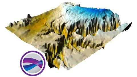
Grids may also be imported from other sources, such as the United States Geological Survey (USGS). The grid is used to produce different types of maps including contour, color relief, and 3D surface maps among others. Many gridding and mapping options are available allowing you to produce the map that best represents your data.
An extensive suite of gridding methods is available in Surfer. The variety of available methods provides different interpretations of your data, and allows you to choose the most appropriate method for your needs. In addition, data metrics allow you to map statistical information about your gridded data.
Surface area, projected planar area, and volumetric calculations can be performed quickly in Surfer. Cross-sectional profiles can also be computed and exported.The grid files can be edited, combined, filtered, sliced, queried, and mathematically transformed. For example, grids can be sliced to create cross-sectional profiles, or the Grids | Calculate | Isopach command can be used to create an isopach map from two grid files. Grids can be edited with an intuitive user interface in the grid editor.
Overview
Section 1: Introduction
Lecture 1 Introduction
Lecture 2 Data Loading and Import
Lecture 3 Creating a Basemap
Lecture 4 Gridding and Contouring
Lecture 5 Map Georeferencing
Lecture 6 Map Printing
Lecture 7 Reservoir Properties Mapping
eople from many different disciplines use Surfer. Since 1984, over 100,000 scientists and engineers worldwide have discovered Surfer's power and simplicity. Surfer's outstanding gridding and contouring capabilities have made Surfer the software of choice for working with XYZ data. Over the years, Surfer users have included hydrologists, engineers, geologists, archeologists, oceanographers, biologists, foresters, geophysicists, medical researchers, climatologists, educators, students, and more! Anyone wanting to visualize their XYZ data with striking clarity and accuracy will benefit from Surfer's powerful features!
Published 9/2022
MP4 | Video: h264, 1280x720 | Audio: AAC, 44.1 KHz
Language: English | Size: 452 MB | Duration: 0h 51m
Download
http://s6.alxa.net/one/2022/09/Grid....in.Surfer.rar
Isopach Mapping in Surfer
What you'll learn
How to Use Surfer
How to Make Basemap in Surfer
How to Make Isopach Maps in Surfer
Different Kind of Contouring & Gridding
Requirements
Anyone can learn this course no prior knowledge of software is require
Description
Introduction to SurferWelcome to Surfer, a powerful contouring, gridding, and surface mapping package for scientists, engineers, educators, or anyone who needs to generate maps quickly and easily. Producing publication quality maps has never been quicker or easier.
Adding multiple map layers and objects, customizing the map display, and annotating with text creates attractive and informative maps. Virtually all aspects of your maps can be customized to produce the exact presentation you want.Surfer is a grid-based mapping program that interpolates irregularly spaced XYZ data into a regularly spaced grid.
Grids may also be imported from other sources, such as the United States Geological Survey (USGS). The grid is used to produce different types of maps including contour, color relief, and 3D surface maps among others. Many gridding and mapping options are available allowing you to produce the map that best represents your data.
An extensive suite of gridding methods is available in Surfer. The variety of available methods provides different interpretations of your data, and allows you to choose the most appropriate method for your needs. In addition, data metrics allow you to map statistical information about your gridded data.
Surface area, projected planar area, and volumetric calculations can be performed quickly in Surfer. Cross-sectional profiles can also be computed and exported.The grid files can be edited, combined, filtered, sliced, queried, and mathematically transformed. For example, grids can be sliced to create cross-sectional profiles, or the Grids | Calculate | Isopach command can be used to create an isopach map from two grid files. Grids can be edited with an intuitive user interface in the grid editor.
Overview
Section 1: Introduction
Lecture 1 Introduction
Lecture 2 Data Loading and Import
Lecture 3 Creating a Basemap
Lecture 4 Gridding and Contouring
Lecture 5 Map Georeferencing
Lecture 6 Map Printing
Lecture 7 Reservoir Properties Mapping
eople from many different disciplines use Surfer. Since 1984, over 100,000 scientists and engineers worldwide have discovered Surfer's power and simplicity. Surfer's outstanding gridding and contouring capabilities have made Surfer the software of choice for working with XYZ data. Over the years, Surfer users have included hydrologists, engineers, geologists, archeologists, oceanographers, biologists, foresters, geophysicists, medical researchers, climatologists, educators, students, and more! Anyone wanting to visualize their XYZ data with striking clarity and accuracy will benefit from Surfer's powerful features!
Published 9/2022
MP4 | Video: h264, 1280x720 | Audio: AAC, 44.1 KHz
Language: English | Size: 452 MB | Duration: 0h 51m
Download
http://s6.alxa.net/one/2022/09/Grid....in.Surfer.rar