SensOre Intrepid Geophysics GeoModeller v4.2.1
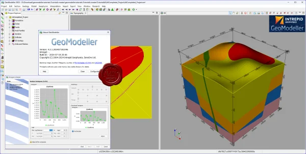
GeoModeller is advanced 3D geological modeling software designed to integrate geological interpretation, geophysical data, and drillhole information into a consistent three-dimensional model of the subsurface. It provides powerful tools for implicit geological modeling, structural analysis, and mineral exploration, helping geoscientists build accurate representations of complex geological environments.
With its advanced implicit 3D geological modeling engine, GeoModeller enables users to create continuous geological surfaces from boreholes, geological maps, cross-sections, stratigraphic relationships, and structural measurements. Its geological modeling capabilities help maintain consistency between rock formations, faults, intrusions, and other geological structures.
GeoModeller geophysical modeling software integrates geological models with magnetic and gravity data through forward modeling, inverse modeling, and joint stochastic inversion workflows. These capabilities help geoscientists compare predicted geophysical responses with observed measurements, evaluate alternative geological interpretations, and assess uncertainty in subsurface models.
The software also supports drillhole data integration, mineral exploration, geological domain modeling, and resource estimation workflows. Advanced techniques such as kriging, inverse distance weighting, Gaussian simulations, and variographic analysis help users interpret geological domains and estimate grade distributions within mineral deposits.
GeoModeller is a valuable solution for geologists, geophysicists, mining engineers, and mineral exploration professionals seeking integrated tools for 3D geological modeling, geophysical interpretation, stochastic inversion, and subsurface resource evaluation. By combining geological constraints with geophysical observations, GeoModeller helps improve geological understanding and support informed exploration and resource assessment decisions.
789MB
Download
🔒 Go Premium to Unlock
GeoModeller is advanced 3D geological modeling software designed to integrate geological interpretation, geophysical data, and drillhole information into a consistent three-dimensional model of the subsurface. It provides powerful tools for implicit geological modeling, structural analysis, and mineral exploration, helping geoscientists build accurate representations of complex geological environments.
With its advanced implicit 3D geological modeling engine, GeoModeller enables users to create continuous geological surfaces from boreholes, geological maps, cross-sections, stratigraphic relationships, and structural measurements. Its geological modeling capabilities help maintain consistency between rock formations, faults, intrusions, and other geological structures.
GeoModeller geophysical modeling software integrates geological models with magnetic and gravity data through forward modeling, inverse modeling, and joint stochastic inversion workflows. These capabilities help geoscientists compare predicted geophysical responses with observed measurements, evaluate alternative geological interpretations, and assess uncertainty in subsurface models.
The software also supports drillhole data integration, mineral exploration, geological domain modeling, and resource estimation workflows. Advanced techniques such as kriging, inverse distance weighting, Gaussian simulations, and variographic analysis help users interpret geological domains and estimate grade distributions within mineral deposits.
GeoModeller is a valuable solution for geologists, geophysicists, mining engineers, and mineral exploration professionals seeking integrated tools for 3D geological modeling, geophysical interpretation, stochastic inversion, and subsurface resource evaluation. By combining geological constraints with geophysical observations, GeoModeller helps improve geological understanding and support informed exploration and resource assessment decisions.
789MB
Download
🔒 Go Premium to Unlock