ESRI ArcGIS Reality Studio 2026.1 x64
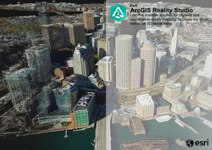
ESRI ArcGIS Reality Studio 2026.1 is a professional reality mapping and photogrammetry platform designed to transform aerial imagery, drone data, and multi-camera captures into high-accuracy 3D meshes, point clouds, True Ortho imagery, and digital surface models for large-scale geospatial projects. It introduces enhanced cloud processing, faster production workflows, and improved Gaussian Splat rendering for more realistic 3D outputs.
Featuring cloud-enabled processing, AI-enhanced reconstruction, advanced Gaussian Splats, automated image alignment, scalable Linux and Windows processing, and precision geospatial modeling, it accelerates reality capture while delivering survey-grade results for cities, infrastructure, and environmental mapping.
Built for GIS professionals, surveyors, mapping specialists, and digital twin developers, ESRI ArcGIS Reality Studio 2026.1 delivers high-performance photogrammetry, seamless ArcGIS integration, and enterprise-scale reality mapping workflows, making it an ideal solution for producing accurate and immersive geospatial datasets.
Core Functions and Features
The new ArcGIS Reality engineBuilt-in new generation core rendering engine with deep optimization for precision, processing speed, and simplicity.
Large-scale real-life mappingDesigned for processing aerial photography data at the city and national scale, it seamlessly integrates aerial images from a variety of sensors.
High-fidelity digital twins: Be able to generate realistic displays (such as high-precision 3D meshes, point clouds, and positive images) that meet the measurement level to build digital twins with highly realistic physical world visual representations.
Intuitive workflowSimplify production processes with guided capture sessions that make it easy for users to align images, add ground control points, and generate product and quality assessments.
2.38GB
Download
🔒 Go Premium to Unlock
ESRI ArcGIS Reality Studio 2026.1 is a professional reality mapping and photogrammetry platform designed to transform aerial imagery, drone data, and multi-camera captures into high-accuracy 3D meshes, point clouds, True Ortho imagery, and digital surface models for large-scale geospatial projects. It introduces enhanced cloud processing, faster production workflows, and improved Gaussian Splat rendering for more realistic 3D outputs.
Featuring cloud-enabled processing, AI-enhanced reconstruction, advanced Gaussian Splats, automated image alignment, scalable Linux and Windows processing, and precision geospatial modeling, it accelerates reality capture while delivering survey-grade results for cities, infrastructure, and environmental mapping.
Built for GIS professionals, surveyors, mapping specialists, and digital twin developers, ESRI ArcGIS Reality Studio 2026.1 delivers high-performance photogrammetry, seamless ArcGIS integration, and enterprise-scale reality mapping workflows, making it an ideal solution for producing accurate and immersive geospatial datasets.
Core Functions and Features
The new ArcGIS Reality engineBuilt-in new generation core rendering engine with deep optimization for precision, processing speed, and simplicity.
Large-scale real-life mappingDesigned for processing aerial photography data at the city and national scale, it seamlessly integrates aerial images from a variety of sensors.
High-fidelity digital twins: Be able to generate realistic displays (such as high-precision 3D meshes, point clouds, and positive images) that meet the measurement level to build digital twins with highly realistic physical world visual representations.
Intuitive workflowSimplify production processes with guided capture sessions that make it easy for users to align images, add ground control points, and generate product and quality assessments.
2.38GB
Download
🔒 Go Premium to Unlock