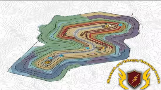
Geological and Mineral Mapping with ArcGIS for Mining
Learn to create geological maps and mineral prospectivity maps using ArcGIS.
What you'll learn
Learn to create geological maps and mineral prospectivity maps using ArcGIS.
Master the use of ArcGIS tools for geostatistical analysis in mining exploration.
Understand how to integrate and analyze geospatial data for mineral resource estimation.
Develop skills in visualizing and interpreting geological and geochemical data for targeted exploration.
Requirements
No prior knowledge is necessary; this course is specifically for beginners who want to start their journey in mining using mining software.
Description
This course is ideal for beginners with no prior knowledge of geology or mining software who are eager to start their journey in the mining industry. It's also perfect for students, geologists, engineers, and environmental professionals looking to enhance their skills in geological mapping and mineral exploration using ArcGIS. If you're looking to gain practical skills in applying GIS to real-world mining challenges, this course is for you.Enhanced Exploration and Resource ModelingIn the exploration phase, software like ArcGIS allows for the precise mapping and analysis of geological data, helping identify potential ore bodies and assess their viability. This leads to more accurate resource modeling, reducing the risks associated with exploration and optimizing investment.Optimized Mine Planning and OperationsFor mine planning, specialized software enables engineers to design optimal mine layouts, evaluate different extraction methods, and simulate production schedules. This ensures the most efficient use of resources and equipment.
During operations, these tools facilitate real-time monitoring of equipment, ore grades, and production targets, allowing for dynamic adjustments and improved productivity.Improved Safety and Environmental ManagementSafety is paramount in mining, and software plays a crucial role in identifying and mitigating risks. It can model geotechnical stability, track personnel, and manage emergency response plans. Furthermore, these applications assist in environmental compliance by monitoring impacts, managing waste, and planning for effective land reclamation.Data-Driven Decision MakingUltimately, mining software provides the data and analytical capabilities needed for informed decision-making. By integrating various data streams—geological, operational, financial, and environmental—it offers a holistic view of the mining enterprise, driving sustainable and profitable outcomes.
Who this course is for
This course is ideal for beginners with no prior knowledge of geology or mining software who are eager to start their journey in the mining industry. It's also perfect for students, geologists, engineers, and environmental professionals looking to enhance their skills in geological mapping and mineral exploration using ArcGIS. If you're looking to gain practical skills in applying GIS to real-world mining challenges, this course is for you.
Last updated 7/2025
Created by Mineral Mentors - Tecnologia de Mineração
MP4 | Video: h264, 1280x720 | Audio: AAC, 44.1 KHz, 2 Ch
Level: Beginner | Genre: eLearning | Language: English | Duration: 10 Lectures ( 3h 27m ) | Size: 1.92 GB
Download
http://s9.alxa.net/one/2025/07/Geolo...for.Mining.rar
Learn to create geological maps and mineral prospectivity maps using ArcGIS.
What you'll learn
Learn to create geological maps and mineral prospectivity maps using ArcGIS.
Master the use of ArcGIS tools for geostatistical analysis in mining exploration.
Understand how to integrate and analyze geospatial data for mineral resource estimation.
Develop skills in visualizing and interpreting geological and geochemical data for targeted exploration.
Requirements
No prior knowledge is necessary; this course is specifically for beginners who want to start their journey in mining using mining software.
Description
This course is ideal for beginners with no prior knowledge of geology or mining software who are eager to start their journey in the mining industry. It's also perfect for students, geologists, engineers, and environmental professionals looking to enhance their skills in geological mapping and mineral exploration using ArcGIS. If you're looking to gain practical skills in applying GIS to real-world mining challenges, this course is for you.Enhanced Exploration and Resource ModelingIn the exploration phase, software like ArcGIS allows for the precise mapping and analysis of geological data, helping identify potential ore bodies and assess their viability. This leads to more accurate resource modeling, reducing the risks associated with exploration and optimizing investment.Optimized Mine Planning and OperationsFor mine planning, specialized software enables engineers to design optimal mine layouts, evaluate different extraction methods, and simulate production schedules. This ensures the most efficient use of resources and equipment.
During operations, these tools facilitate real-time monitoring of equipment, ore grades, and production targets, allowing for dynamic adjustments and improved productivity.Improved Safety and Environmental ManagementSafety is paramount in mining, and software plays a crucial role in identifying and mitigating risks. It can model geotechnical stability, track personnel, and manage emergency response plans. Furthermore, these applications assist in environmental compliance by monitoring impacts, managing waste, and planning for effective land reclamation.Data-Driven Decision MakingUltimately, mining software provides the data and analytical capabilities needed for informed decision-making. By integrating various data streams—geological, operational, financial, and environmental—it offers a holistic view of the mining enterprise, driving sustainable and profitable outcomes.
Who this course is for
This course is ideal for beginners with no prior knowledge of geology or mining software who are eager to start their journey in the mining industry. It's also perfect for students, geologists, engineers, and environmental professionals looking to enhance their skills in geological mapping and mineral exploration using ArcGIS. If you're looking to gain practical skills in applying GIS to real-world mining challenges, this course is for you.
Last updated 7/2025
Created by Mineral Mentors - Tecnologia de Mineração
MP4 | Video: h264, 1280x720 | Audio: AAC, 44.1 KHz, 2 Ch
Level: Beginner | Genre: eLearning | Language: English | Duration: 10 Lectures ( 3h 27m ) | Size: 1.92 GB
Download
http://s9.alxa.net/one/2025/07/Geolo...for.Mining.rar